

Earth, wind and readiness: Preparing for poor air quality, and the Big One
The CA Dose July 2, 2026

This week’s focus is staying safe and informed when we face threats in the air we breathe or from the ground beneath us.
Reading the air: Where to go to know your air quality
With increasing wildfires, the number of “bad air days” in California is growing, and many of us (including me) are getting more interested in knowing the quality of the air we’re breathing.
If you’ve tried to search the local air quality when the skies get smoky, you know: it can be confusing! There are different answers depending on where you look, and the most popular apps and websites don’t always match what authorities are saying. Here’s a quick breakdown of why that is, and tips for finding the most reliable source.
The big picture: The methods for monitoring air quality aren’t as settled as they are for other weather factors like temperature, rain, or wind, but they’re improving. The readings we get are based on data sent from air monitors positioned around our communities. Our air is measured by two main types of devices:
Private lower-cost sensors that your neighbors may have purchased for home use (e.g. PurpleAir).
Government “regulation grade” monitors, calibrated regularly for high accuracy.
Each has strengths and weaknesses that are worth understanding.
PurpleAir: Fast, dense, and slightly less accurate
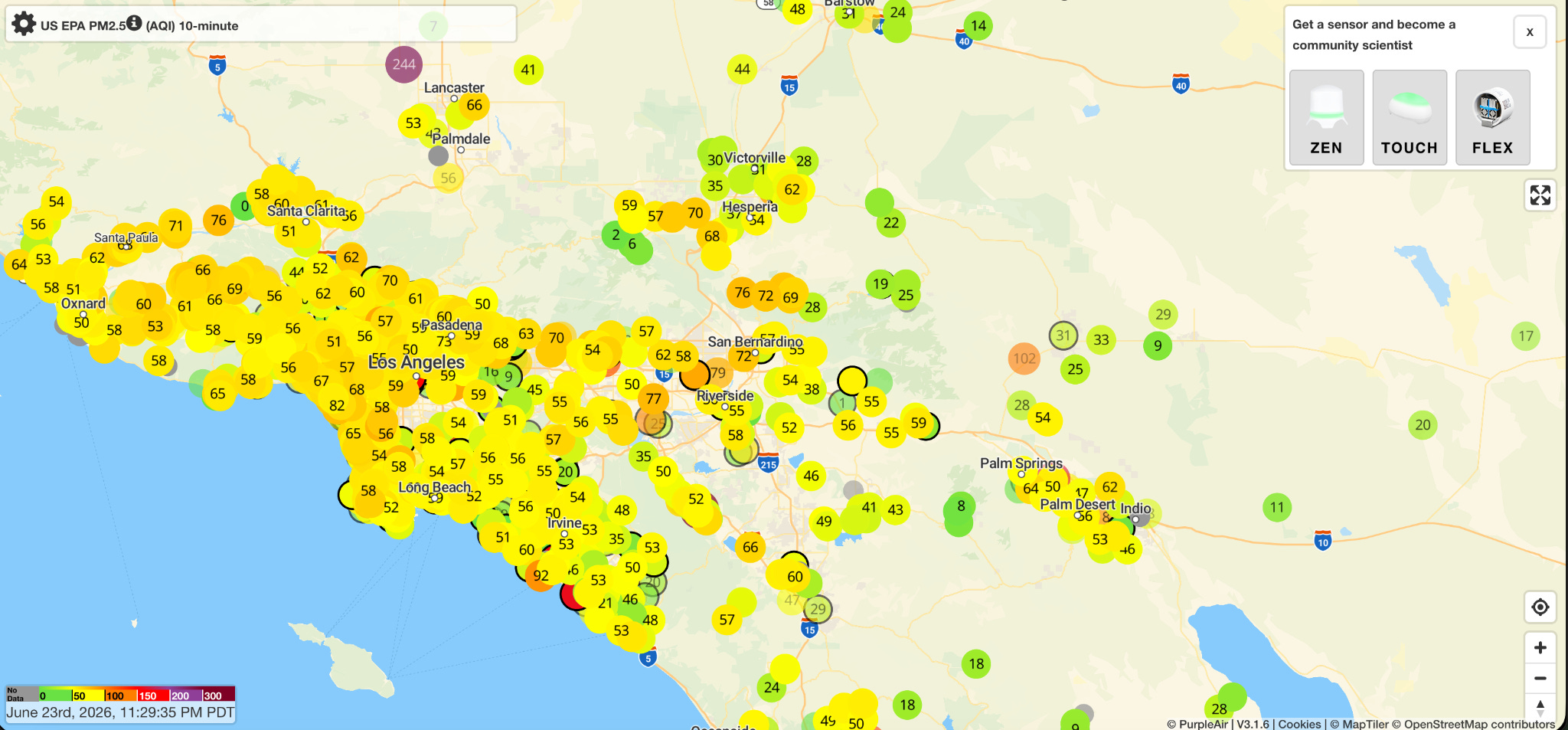
PurpleAir sensors are the community science side of air quality monitoring. They cost $200-300 — affordable enough that many families, schools, and community groups can mount one on a porch or outside wall; each monitor lets the installer see their own air quality up close and feeds real-time data into a public map. The network has grown to tens of thousands of sensors worldwide and up to 8,000 in California alone.
The trade off is accuracy. PurpleAir sensors use a laser-scattering method to estimate particle mass rather than measure it directly, and this gets less precise as air quality worsens.
PurpleAir is almost too sensitive. It reports air quality at the place and time of the measurement every ten minutes— an idling bus, local construction, or a brief wind pattern can cause one home’s readings to differ from another just down the street, or with the nearest official station on the map.
The PurpleAir website offers maps that allow you to see the readings from all sensors in your area, individually.
AirNow.gov Slow, sparse, and more accurate
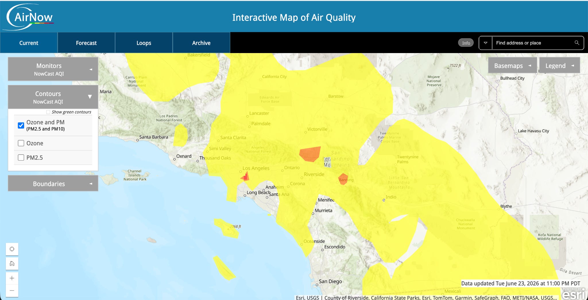
In California, air quality has its own regulatory network, organized into multi-county regions. In the Los Angeles area, the regional authority — South Coast Air Quality Management District — operates roughly 40 permanent air monitoring stations throughout a four-county basin. The Bay Area Air Quality Management District runs 17 stations. The federal EPA provides oversight, and these are the highest-quality instruments, professionally calibrated, sited by trained technicians.
The results of these monitors are what you find on the popular AirNow.gov website.
The downside is the government monitors are few and far between. They update hourly, not in real-time, and the nearest one might be miles away. They’re highly accurate, but not always as locally relevant. Here’s what the output of these monitors looks like on AirNow.gov– less granular, and updated less often.
So, how do we combine the power of the network of many low-cost home sensors with the strengths of the more precise regulatory monitors at AirNow.gov?
The Fire and Smoke Map: One site combining both kinds of data
You don’t have to choose between PurpleAir’s density and the regulatory network’s accuracy, because the EPA, US Forest Service and PurpleAir built a map that gives you both.
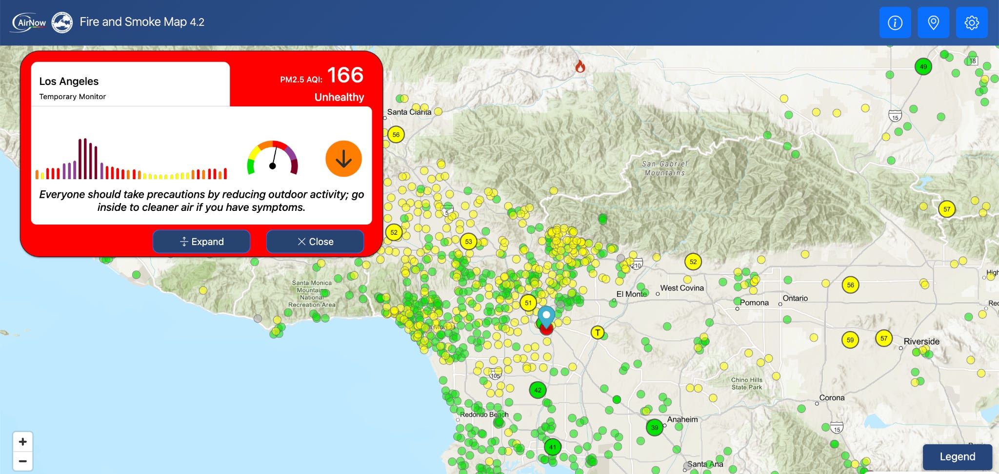
The AirNow Fire and Smoke Map layers PurpleAir sensor readings alongside both official regulatory monitors and satellite-detected smoke plumes, all on one screen. (This is different from the basic EPA “AirNow” map above; make sure you’re using the “Fire and Smoke” version.) PurpleAir data appears on the map, EPA applies a correction equation that “smoothes out” outlying readings to provide a more accurate picture.
During wildfire season — which is now most of the year in California — fire.airnow.gov is my first stop. Here’s what the AirNow Fire and Smoke dashboard looked like last week during the Lineage facility fire, when I clicked on the one high reading by the warehouse in Boyle Heights.
Other emerging tools integrate crowd-sourced and government air quality monitoring into a single platform, including IQAir and some of the regional air district monitoring sites, like LA’s South Coast AQMD. But I prefer the Fire and Smoke version, partly because it also offers data on the range and direction of smoke plumes from wildfires using satellite data.
We’re learning more about the health harms associated with breathing polluted air, and the measures we can take to protect ourselves. Knowing your local air quality is the first step we can all take to understand our environment and protect ourselves.
Earthquake readiness: Now’s the time
This week, we were rocked by news of the earthquake in Venezuela, while many of us experienced quakes closer to home, with a 5.6 earthquake centered in Redwood Valley on June 24 at 8:10 a.m. Many of us in the Bay Area received earthquake alerts that looked like this.

Over the weekend, we asked panelists in The Pulse, our weekly survey of a select, representative group of Californians, this question; and the results aren’t reassuring.

Fewer than one in ten respondents felt “very prepared,” and about a third were “not at all prepared”. Of course it’s hard to feel totally prepared for a devastating earthquake, but we can do better than that.
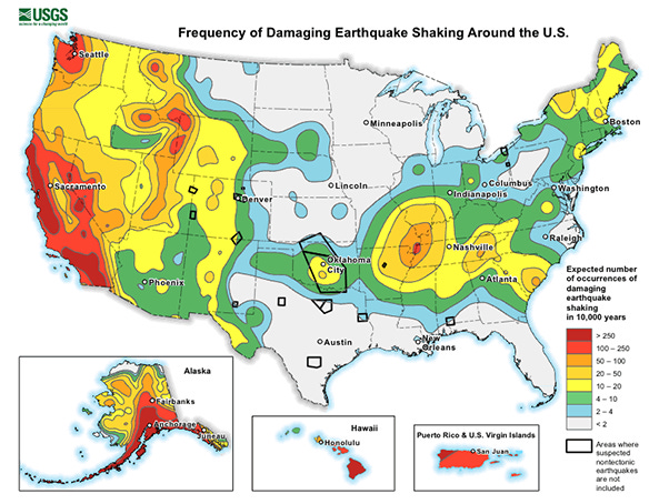
Growing up in California, I’ve heard about “the big one” my whole life. It’s part of our culture. I remember being excited every year for the Great California Shakeout, our statewide earthquake drill. Research suggests we’re due for another major earthquake, but many of us haven’t taken the time to prepare an action plan.
Here are some key steps to take, to prepare, and to respond when shaking starts.
Prepare: things you can do now
Get the alerts
WEA (Wireless Emergency Alert) — The alert I got last week is the same automatic, no-signup system that delivers AMBER Alerts. WEA’s are sent to everyone with a wireless phone in a certain radius of an earthquake magnitude 5.0 or greater. The Redwood Valley quake was 5.6. I didn’t end up feeling any shaking, but knew it might come. On most phones, this is turned on by default. Juts double check your phones to make sure everyone in your family has “emergency alerts” on in your notification settings.
MyShake: If you want even more early warning, the MyShake app is free and made by UC Berkeley. Unlike WEA, it’s opt-in: you become part of a network that supplies and receives data, kind of like PurpleAir. Your phone helps detect shaking, and in return you get faster, more sensitive alerts — MyShake delivers alerts within five seconds, and triggers at a lower threshold (magnitude 4.5+, light shaking) than WEA’s 5.0+ cutoff.Secure heavy furniture. Anchor bookcases, TVs, and water heaters to the wall. In the 1994 Northridge earthquake, most injuries were caused by falling furniture or objects, while only 1% came from building damage itself. (This highlights a critical difference between California and other settings, like Venezuela. For decades, our buildings have been built with earthquake risk in mind, and are more resilient to shaking than those elsewhere.)
Make a family plan. Cell networks often jam or are damaged right after a quake. Pick someone out-of-area to be a common contact person for the whole family, and pick a meeting spot. Don’t forget pets: know how you’d transport or shelter them.
Pack an evacuation kit: Packing essentials like water, nonperishable foods, and a week’s worth of any essential medication helps you to evacuate quickly in any disaster. Include medical records, pictures of family, and important documentation in case anyone is displaced. The state offers a comprehensive earthquake readiness guide with a checklist.
Practice Drop, Cover, Hold On. Walk your home and identify safe spots in each room away from windows, mirrors, or high shelves to move to when shaking starts.
Respond: When the shaking starts
Drop, Cover, Hold On. Get low, take cover under sturdy furniture, protect your head and neck, and hold on until shaking stops.
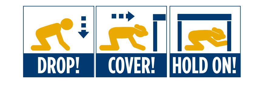
Don’t run. Trying to get outside during shaking increases your injury risk— if you’re inside, stay where you are and take cover. If you’re outside, stay outside and try to move to an open area away from buildings, power lines, and streetlights.
Stay put until it’s over, then check yourself and others for injuries before moving around, since aftershocks and broken glass are common.
Lean on your plan. If it’s a major quake, and cell service is down, your prep work pays off: pull out your go-bag, use your family communication plan and meeting spot if you’re separated, and check on pets. You’ll be glad you didn’t leave it for the day of.
Bottom line
We can’t control when the air turns hazardous or when the ground shakes. But we can control how much we know and how ready we are: checking the Fire and Smoke Map, anchoring the bookcase, packing the go-bag, getting earthquake alerts. The threat may be out of our hands, but our response doesn’t have to be.
Note: The YLE team is off next week. I’ll see you in two weeks. Happy 4th of July!
Love,
Matt
Dr. Matt Willis is the author of Your Local Epidemiologist in California. A California native, he’s served as a primary care physician, CDC epidemiologist, and public health officer for Marin County, where he guided the pandemic response. He lives in Marin with his family and their dogs Teddy and Ramona.